Today was a step in the warmer direction, but only a half-step. There are warmer days ahead, but the pattern that has ruled since early to mid December really doesn’t seem to want to let go until next month.
Hard to swallow, I know.
It’s at this point in spring that many folks start to question what might be behind this cold….and the mild, windy winter in Europe, AND the 60s in mid January in Alaska – what, you didn’t know other places were that warm?
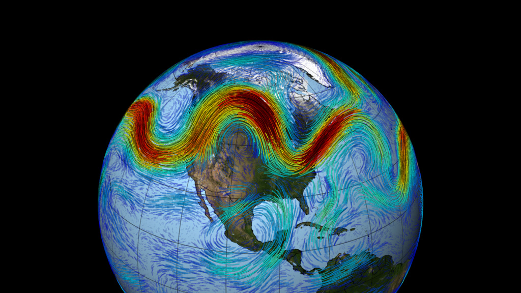
Unlike politics, weather is NOT local. It’s a global phenomenon: at the whimsy of the seasons, the oceans and what we call atmospheric oscillations. When one spot is warm, the other, “downstream” (often to the east in the Northern Hemisphere) is cold. Follow the undulations (reflected in the jetstream) around the globe, and you have what we often refer to as “the pattern”, or more emphatically, a mode of variability.
Still with me? Good.
These oscillations – or modes – have names, depending on their location and regions of control. For reasons of simplicity, we’ll focus on the two that cause us the most grief/elation in New England: the North American Oscillation (NAO) and the Pacific North American Oscillation (PNA).
All was going well in early December as winter closed in. The West Coast seemed to be in a normal pattern, we had our 1st frost, and much anticipation was building in the weather world about the type of winter we could see. Cold? Warm? Snowbound or snow drought? Then the numbing cold hit the Intermountain West. It was a fierce, Siberian cold that they hadn’t seen the likes of in years. Rivers, lakes, ponds skimmed over in days. According to my former classmate who worked/lived in Boulder, Colorado, “Folks here don’t know how to deal with this.” In fact, many meteorologists/climatologists wondered what could have pried such a bitter airmass away from that part of the world so early in the season.
The search was on to find a culprit for the arctic gateway that opened to Eastern Russia. Meteorologists looked no further than the gargantuan high pressure system sitting off the West Coast and sealing off the storms to California, Washington and Oregon. The PNA pattern was at work again, but what made this episode so unique was that it had support from a pool of extremely warm (for the North Pacific anyway) water stirring underneath (see pictures above).
This is what we call a “positive feedback”: ocean warms atmosphere, warm atmosphere keeps ocean warm. Note that this continued for three months, locking the lower 48 in arctic air for weeks on end, and creating a persistent (and overhyped) polar vortex over Central North America.
There are some circles of meteorologist who contend that in the Rock, Paper, Scissors world of atmospheric oscillations, the PNA is the one pattern to rule them all in North America. It provides a more direct influence in temperatures and precipitation than the much ballyhooed NAO or Arctic Oscillation, they say. And when it’s in lock step with the ocean, only a major seasonal shift can stem the tide. (Translated: give it until April to shake out.)
I don’t know if I agree. There are very few absolutes in meteorology. The North Atlantic Oscillation can be a major player in the weather too, squeezing New England with cold/snow or warmth/rain at times – but it’s hardly a slam dunk. The signals for it can be misleading depending on which side of Greenland the pattern sets up, and numbers that point to snow and cold don’t always pan out that way.
So what kind of takeaway can we glean for future seasonal forecasts? Well, with climate change slowing the jet stream by up to 14%,
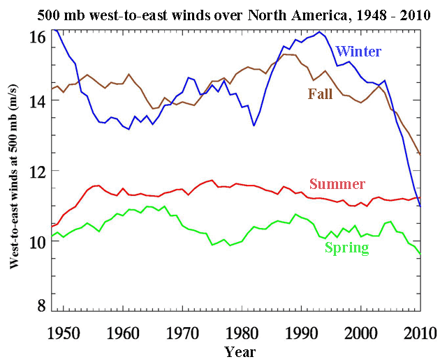
[West-to-east jet stream wind speeds at 500 mb (approximately 18,000 feet or 5,600 meters) in the mid-latitudes (40 – 60°N) over North America between 1948 and 2010. During fall (October – November – December) and winter (January – February – March), jet stream winds weakened by about 20%, from 13 – 14 m/s to 10.5 – 11 m/s. Spring (AMJ) and summer (JAS) winds changed little during this time period.] (Courtesy: Dr. Jennifer Francis, Rutgers University)
patterns are becoming stagnant and easier to detect. When they lock, they lock and sometimes throw away the key (see cold, wet summer of 2009). Does this make them more predictable? Possibly. And coupled with warm/cold pools in the major oceans of the world, we could certainly have a better idea of what to expect in the weeks – or possibly months – ahead.
Of course, this is the holy grail of weather forecasting. Imagine the cost savings to business and commodities that have access to these forecasts! There’s much to be learned from these oscillations, and much to be gained.
So now you have insight into what may have been behind the cold/snow this winter. Interesting to note that although there were a number of top ten coldest winters in the Upper Midwest, NO ONE along the Eastern Seaboard made it.
That’s all you got, Old Man Winter?
🙂
Pete